|
|
Antenna Structure Registration 1041043 |
 |
Registration Info | Registration Number: 1041043 |
| File Number: A0048337 |
| FAA Study: 98-ASO-0928-OE |
| FAA Issue Date: 02/13/1998 |
| Status: Constructed |
| Date Constructed: 01/01/1973 |
| NEPA: N |
Structure Info
| Structure Type: TOWER |
| Structure Coordinates: 34-16-24.0 N 89-9-7.0 W (NAD 83) |
| Structure Coordinates: 34-16-23.6 N 89-09-06.8 W (Converted to NAD 27) |
| Structure Address: 1.2 Km S Of Hwy 6 |
| Structure City: Thaxton, MS |
| Structure County: Pontotoc County |
| Painting & Lighting Info |
FAA Circular #: 70/7460-1J |
FAA Chapters: 3, 4, 5, 13 |
Remarks: REF STUDY #97-ASO-6080-OE |
| Elevation Info |
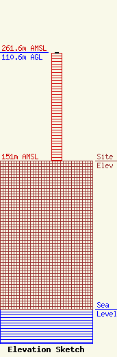
Site Elevation: 151 meters (495 ft) |
| Height of Structure: 110 meters (361 feet) |
| Overall Height Above Ground: 110.6 meters (363 feet) |
| Overall Height Above Mean Sea Level: 261.6 meters (858 feet) |
| Owner Info | MISSISSIPPI AUTHORITY FOR EDUCATIONAL TELEVISION
3825 RIDGEWOOD ROAD
JACKSON, MS 39211-6463
(601) 982-6565
|
