|
|
Antenna Structure Registration 1041065 |
 |
Registration Info | Registration Number: 1041065 |
| File Number: A1297366 |
| FAA Study: 98-ASO-4097-OE |
| FAA Issue Date: 07/17/1998 |
| Status: Constructed |
| Date Constructed: 05/26/1953 |
| FAA EMI: N |
| NEPA: N |
Structure Info
| Structure Type: TOWER |
| Structure Coordinates: 32-19-39.0 N 88-41-28.0 W (NAD 83) |
| Structure Coordinates: 32-19-38.5 N 88-41-27.8 W (Converted to NAD 27) |
| Structure Address: Us Highway 145 1.8 Miles South |
| Structure City: Meridian, MS |
| Structure County: Lauderdale County |
| Painting & Lighting Info |
FAA Circular #: 70/7460-1J |
FAA Chapters: 3, 4, 5, 13 |
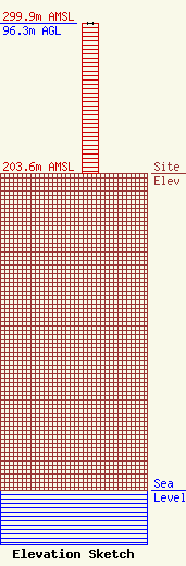
| Elevation Info |
Site Elevation: 203.6 meters (668 ft) |
| Height of Structure: 96.3 meters (316 feet) |
| Overall Height Above Ground: 96.3 meters (316 feet) |
| Overall Height Above Mean Sea Level: 299.9 meters (984 feet) |
| Owner Info | Gray Local Media, Inc.
4370 Peachtree Road, NE
Atlanta, GA 30319
(404) 266-8333
legalnotices@graymedia.com |
| Contact Info | Gray Local Media, Inc.
4370 Peachtree Road NE
Atlanta, GA 30319
Engineering Department
(404) 266-8333
legalnotices@graymedia.com |
