|
|
Antenna Structure Registration 1041127 |
 |
Registration Info | Registration Number: 1041127 |
| File Number: A0048439 |
| FAA Study: 84-ASW-1727-OE |
| FAA Issue Date: 08/31/1984 |
| Status: Constructed |
| Date Constructed: 01/01/1987 |
| NEPA: N |
Structure Info
| Structure Type: TOWER |
| Structure Coordinates: 34-47-31.0 N 92-28-39.0 W (NAD 83) |
| Structure Coordinates: 34-47-30.7 N 92-28-38.4 W (Converted to NAD 27) |
| Structure Address: Crystal Mountain W |
| Structure City: Little Rock, AR |
| Structure County: Pulaski County |
| Painting & Lighting Info |
FCC Paragraph(s): 1, 3, 12, 21 |
Remarks: RED LIGHTS/PAINT |
| Elevation Info |
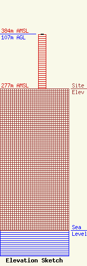
Site Elevation: 277 meters (909 ft) |
| Height of Structure: 106 meters (348 feet) |
| Overall Height Above Ground: 107 meters (351 feet) |
| Overall Height Above Mean Sea Level: 384 meters (1260 feet) |
| Owner Info | ARKANSAS BROADCASTING FOUNDATION INC DBA = KABF
1501 ARCH ST
LITTLE ROCK, AR 72202
(501) 372-6119
|
