|
|
Antenna Structure Registration 1041589 |
 |
Registration Info | Registration Number: 1041589 |
| File Number: A0049030 |
| FAA Study: 81-ASO-823-OE |
| FAA Issue Date: 05/07/1981 |
| Status: Granted |
| NEPA: N |
Structure Info
| Structure Type: TOWER |
| Structure Coordinates: 31-16-51.0 N 90-27-5.0 W (NAD 83) |
| Structure Coordinates: 31-16-50.4 N 90-27-04.6 W (Converted to NAD 27) |
| Structure Address: 1006 Robb Street Ext. E |
| Structure City: Summit, MS |
| Structure County: Pike County |
| Painting & Lighting Info |
FCC Paragraph(s): 1, 3, 4, 13, 21 |
Remarks: RED LIGHTS/PAINT |
| Elevation Info |
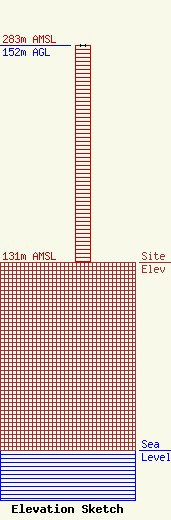
Site Elevation: 131 meters (430 ft) |
| Height of Structure: 152 meters (499 feet) |
| Overall Height Above Ground: 152 meters (499 feet) |
| Overall Height Above Mean Sea Level: 283 meters (928 feet) |
| Owner Info | SOUTHWEST BROADCASTING INC.
206 N. FRONT STREET
P.O. BOX 1649
MCCOMB, MS 39649-1649
(601) 684-4116
|
