|
|
Antenna Structure Registration 1041601 |
 |
Registration Info | Registration Number: 1041601 |
| File Number: A0049048 |
| FAA Study: 93-AGL-1953-OE |
| FAA Issue Date: 06/04/1993 |
| Status: Constructed |
| Date Constructed: 10/30/1997 |
| NEPA: N |
Structure Info
| Structure Type: TOWER |
| Structure Coordinates: 41-2-21.0 N 86-30-55.0 W (NAD 83) |
| Structure Coordinates: 41-02-20.9 N 86-30-55.0 W (Converted to NAD 27) |
| Structure Address: Cr 405e 0.2 Km N Of Cr125s |
| Structure City: Winamac, IN |
| Structure County: Pulaski County |
| Painting & Lighting Info |
FAA Circular #: 70/7460-1H |
FAA Chapters: 3, 4, 5, 13 |
| Elevation Info |
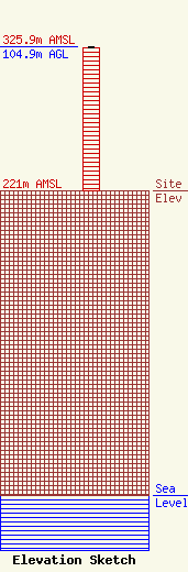
Site Elevation: 221 meters (725 ft) |
| Height of Structure: 103.9 meters (341 feet) |
| Overall Height Above Ground: 104.9 meters (344 feet) |
| Overall Height Above Mean Sea Level: 325.9 meters (1069 feet) |
| Owner Info | PROGRESSIVE BROADCASTING SYSTEM DBA = WFRI RADIO
307
ELKHART, IN 46515
(219) 875-5166
|
