|
|
Antenna Structure Registration 1041714 |
 |
Registration Info | Registration Number: 1041714 |
| File Number: A1181351 |
| FAA Study: 78-RM-525-OE |
| Status: Constructed |
| Date Constructed: 01/01/1978 |
| FAA EMI: N |
| NEPA: N |
Structure Info
| Structure Type: TOWER |
| Structure Coordinates: 47-8-21.0 N 100-42-22.0 W (NAD 83) |
| Structure Coordinates: 47-08-21.0 N 100-42-20.5 W (Converted to NAD 27) |
| Structure Address: 4 Mi Se |
| Structure City: Wilton, ND |
| Structure County: Burleigh County |
| Painting & Lighting Info |
FCC Paragraph(s): 1, 3, 11, 21 |
| Elevation Info |
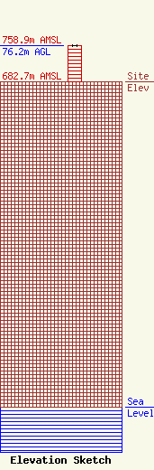
Site Elevation: 682.7 meters (2240 ft) |
| Height of Structure: 76.2 meters (250 feet) |
| Overall Height Above Ground: 76.2 meters (250 feet) |
| Overall Height Above Mean Sea Level: 758.9 meters (2490 feet) |
| Owner Info | Otter Tail Power Company
215 South Cascade Street
Fergus Falls, MN 56537
(218) 739-8584
mberlinger@otpco.com |
| Contact Info | Otter Tail Power Company
215 South Cascade Street
Fergus Falls, MN 56537
Marty Berlinger
(218) 739-8584
mberlinger@otpco.com |
