|
|
Antenna Structure Registration 1041734 |
 |
Registration Info | Registration Number: 1041734 |
| File Number: A0049198 |
| FAA Study: 97-AGL-3492-OE |
| FAA Issue Date: 08/18/1997 |
| Status: Constructed |
| Date Constructed: 01/01/1978 |
| NEPA: N |
Structure Info
| Structure Type: TOWER |
| Structure Coordinates: 39-18-52.0 N 82-8-59.0 W (NAD 83) |
| Structure Coordinates: 39-18-51.7 N 82-08-59.5 W (Converted to NAD 27) |
| Structure Address: County Road 19 |
| Structure City: Athens, OH |
| Structure County: Athens County |
| Painting & Lighting Info |
FAA Circular #: 70/7460-1J |
FAA Chapters: 3, 4, 5, 13 |
| Elevation Info |
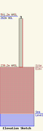
Site Elevation: 239.2 meters (785 ft) |
| Height of Structure: 250.1 meters (821 feet) |
| Overall Height Above Ground: 262 meters (860 feet) |
| Overall Height Above Mean Sea Level: 501.2 meters (1644 feet) |
| Owner Info | OHIO UNIVERSITY TELECOM CENTER DBA = WOUB-FM/TV
9 SOUTH COLLEGE STREET
ATHENS, OH 45701-2905
(740) 593-1771
DWISEMAN1@OHIOU.EDU |
