|
|
Antenna Structure Registration 1042108 |
 |
Registration Info | Registration Number: 1042108 |
| File Number: A1297382 |
| FAA Study: 97-AGL-5816-OE |
| FAA Issue Date: 03/13/1998 |
| Status: Constructed |
| Date Constructed: 02/10/1997 |
| FAA EMI: N |
| NEPA: N |
Structure Info
| Structure Type: TOWER |
| Structure Coordinates: 44-20-22.0 N 96-46-8.0 W (NAD 83) |
| Structure Coordinates: 44-20-22.1 N 96-46-06.8 W (Converted to NAD 27) |
| Structure Address: 1.5 Km Nw Of Jct By-pass Rt 14 & Sr 29/77 |
| Structure City: Brookings, SD |
| Structure County: Brookings County |
| Painting & Lighting Info |
FAA Circular #: 70/7460-1J |
FAA Chapters: 4, 8, 13 |
Remarks: REPLACES 96-AGL-0530-OE. |
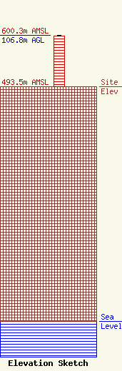
| Elevation Info |
Site Elevation: 493.5 meters (1619 ft) |
| Height of Structure: 106 meters (348 feet) |
| Overall Height Above Ground: 106.8 meters (350 feet) |
| Overall Height Above Mean Sea Level: 600.2 meters (1969 feet) |
| Owner Info | Gray Local Media, Inc.
4370 Peachtree Road, NE
Atlanta, GA 30319
(404) 266-8333
legalnotices@graymedia.com |
| Contact Info | Gray Local Media, Inc.
4370 Peachtree Road NE
Atlanta, GA 30319
Engineering Department
(404) 266-8333
legalnotices@graymedia.com |
