|
|
Antenna Structure Registration 1042287 |
 |
Registration Info | Registration Number: 1042287 |
| File Number: A1194771 |
| FAA Study: 2018-ASO-14021-OE |
| FAA Issue Date: 12/13/2018 |
| Status: Constructed |
| Date Constructed: 01/01/1987 |
| NEPA: N |
Structure Info
| Structure Type: GTOWER |
| Structure Coordinates: 31-24-19.4 N 89-14-14.8 W (NAD 83) |
| Structure Coordinates: 31-24-18.8 N 89-14-14.6 W (Converted to NAD 27) |
| Structure Address: 4 Mi Ne Of Petal On Lynn Ray Rd |
| Structure City: Hattiesburg, MS |
| Structure County: Forrest County |
| Painting & Lighting Info |
FCC Paragraph(s): 1, 3, 5, 14, 21 |
Remarks: PRIOR STUDY 2015-ASO-10212-OE |
Remarks: Continue As Is OM&L = PAINT/RED LIGHTS |
Remarks: PRIOR STUDY 2015-ASO-10212-OE |
Remarks: Continue As Is OM&L = PAINT/RED LIGHTS |
| Elevation Info |
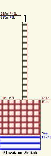
Site Elevation: 94 meters (308 ft) |
| Height of Structure: 207 meters (679 feet) |
| Overall Height Above Ground: 225 meters (738 feet) |
| Overall Height Above Mean Sea Level: 319 meters (1047 feet) |
| Owner Info | Nexstar Media Inc.
545 E. John Carpenter Freeway
Irving, TX 75062
(972) 373-8800
jasroberts@nexstar.tv |
| Contact Info | Nexstar Media Inc.
545 E. John Carpenter Freeway
Irving, TX 75062
Jason Roberts
(972) 373-8800
jasroberts@nexstar.tv |
