|
|
Antenna Structure Registration 1042294 |
 |
Registration Info | Registration Number: 1042294 |
| File Number: A1197555 |
| FAA Study: 79-ANE-152-OE3 |
| FAA Issue Date: 05/07/1981 |
| Status: Dismantled |
| Date Constructed: 01/01/1981 |
| FAA EMI: N |
| NEPA: N |
Structure Info
|
| Structure Coordinates: 44-29-46.1 N 73-12-47.1 W (NAD 83) |
| Structure Coordinates: 44-29-45.9 N 73-12-48.6 W (Converted to NAD 27) |
| Structure Address: Twr 3 Intervale Rd |
| Structure City: Burlington, VT |
| Structure County: Chittenden County |
| Painting & Lighting Info |
FAA Chapters: NONE |
| Elevation Info |
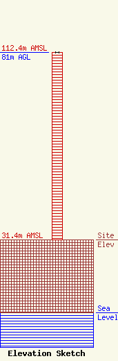
Site Elevation: 31.4 meters (103 ft) |
| Height of Structure: 81 meters (266 feet) |
| Overall Height Above Ground: 81 meters (266 feet) |
| Overall Height Above Mean Sea Level: 112.4 meters (369 feet) |
| Owner Info | Independent Digital & Wireless, Inc.
288 S. River Rd
Bedford, NH 03110
(603) 668-6400
flanagan@pointfm.com |
| Contact Info | Independent Digital & Wireless, Inc.
288 S. River Rd
Bedford, NH 03110
Lisa Burgess
(603) 668-9999
lisab@nebcast.com |
