|
|
Antenna Structure Registration 1042620 |
 |
Registration Info | Registration Number: 1042620 |
| File Number: A1261497 |
| FAA Study: 94-ASO-2286-OE |
| Status: Dismantled |
| Date Constructed: 07/01/1956 |
| FAA EMI: N |
| NEPA: N |
Structure Info
|
| Structure Coordinates: 36-0-21.0 N 83-56-20.0 W (NAD 83) |
| Structure Coordinates: 36-00-20.7 N 83-56-20.3 W (Converted to NAD 27) |
| Structure Address: 601 Memorial Parkway |
| Structure City: Knoxville, TN |
| Structure County: Knox County |
| Painting & Lighting Info |
FAA Chapters: NONE |
| Elevation Info |
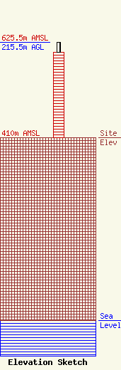
Site Elevation: 410 meters (1345 ft) |
| Height of Structure: 191.7 meters (629 feet) |
| Overall Height Above Ground: 215.5 meters (707 feet) |
| Overall Height Above Mean Sea Level: 625.4 meters (2052 feet) |
| Owner Info | WBIR-TV, LLC
8350 Broad Street, Suite 2000
Tysons, VA 22102
(703) 873-6902
mbeder@TEGNA.com |
| Contact Info | WBIR-TV, LLC
8350 Broad Street, Suite 2000
Tysons, VA 22102
Denise Branson
(703) 873-6606
dbranson@TEGNA.com |
