|
|
Antenna Structure Registration 1042763 |
 |
Registration Info | Registration Number: 1042763 |
| File Number: A1251775 |
| FAA Study: 2014-ASO-8387-OE |
| FAA Issue Date: 09/09/2014 |
| Status: Constructed |
| Date Constructed: 06/10/2022 |
| NEPA: N |
Structure Info
| Structure Type: GTOWER |
| Structure Coordinates: 35-12-26.0 N 85-16-52.0 W (NAD 83) |
| Structure Coordinates: 35-12-25.7 N 85-16-52.1 W (Converted to NAD 27) |
| Structure Address: Sawyer Cemetery Rd |
| Structure City: Signal Mountain, TN |
| Structure County: Hamilton County |
| Painting & Lighting Info |
FAA Circular #: 70/7460-1K |
FAA Chapters: 3, 4, 5, 12 |
Remarks: PRIOR STUDY 1992-ASO-1871-OE |
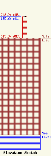
| Elevation Info |
Site Elevation: 613.3 meters (2012 ft) |
| Height of Structure: 135.6 meters (445 feet) |
| Overall Height Above Ground: 135.6 meters (445 feet) |
| Overall Height Above Mean Sea Level: 748.9 meters (2457 feet) |
| Owner Info | GREATER CHATTANOOGA PUBLIC TELEVISION CORPORATION
7540 Bonnyshire Drive
CHATTANOOGA, TN 37416
(423) 702-7800
bfuqua@wtcitv.org |
| Contact Info | Greater Chattanooga Public Television Corporation
7540 Bonnyshire Drive
Chattanooga, TN 37416
Bryan Fuqua
(423) 702-7800
bfuqua@wtcitv.org |
