|
|
Antenna Structure Registration 1042885 |
 |
Registration Info | Registration Number: 1042885 |
| File Number: A0675895 |
| FAA Study: 81-ASO-316-OE |
| FAA Issue Date: 11/24/1981 |
| Status: Constructed |
| Date Constructed: 01/01/1981 |
| FAA EMI: N |
| NEPA: N |
Structure Info
| Structure Type: TOWER |
| Structure Coordinates: 38-2-44.0 N 84-39-29.0 W (NAD 83) |
| Structure Coordinates: 38-02-43.7 N 84-39-29.2 W (Converted to NAD 27) |
| Structure Address: 3950 Lexington Rd |
| Structure City: Versailles, KY |
| Structure County: Woodford County |
| Painting & Lighting Info |
FAA Circular #: 70/7460-1F |
FAA Chapters: 3, 4, 5, 9 |
Remarks: RED LIGHTS/PAINT |
| Elevation Info |
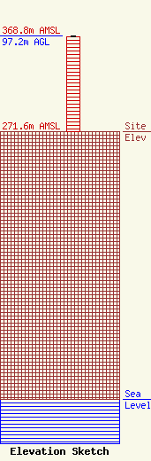
Site Elevation: 271.6 meters (891 ft) |
| Height of Structure: 96.2 meters (316 feet) |
| Overall Height Above Ground: 97.2 meters (319 feet) |
| Overall Height Above Mean Sea Level: 368.8 meters (1210 feet) |
| Owner Info | L.M. Communications, Inc
401 West Main Street, Suite 301
Lexington, KY 40507
(859) 233-1515
charlie@b92fm.com |
| Contact Info | L.M. Communications, Inc.
401 West Main Street, Suite 301
Lexington, KY 40507
Charles Kendall
(859) 233-1515
charlie@b92fm.com |
