|
|
Antenna Structure Registration 1042943 |
 |
Registration Info | Registration Number: 1042943 |
| File Number: A0050590 |
| Status: Constructed |
| Date Constructed: 03/01/1954 |
| NEPA: N |
Structure Info
| Structure Type: TOWER |
| Structure Coordinates: 35-58-23.0 N 83-12-49.0 W (NAD 83) |
| Structure Coordinates: 35-58-22.7 N 83-12-49.4 W (Converted to NAD 27) |
| Structure Address: 640 W Hwy 25 70 |
| Structure City: Newport, TN |
| Structure County: Cocke County |
| Painting & Lighting Info |
FCC Paragraph(s): 1, 3, 11, 21 |
| Elevation Info |
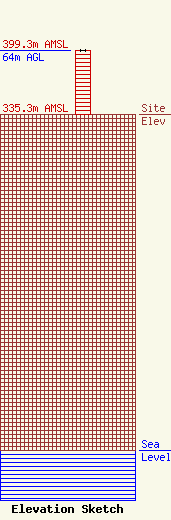
Site Elevation: 335.3 meters (1100 ft) |
| Height of Structure: 64 meters (210 feet) |
| Overall Height Above Ground: 64 meters (210 feet) |
| Overall Height Above Mean Sea Level: 399.3 meters (1310 feet) |
| Owner Info | WLIK INC
640 W HWY 25 70
NEWPORT, TN 37821
(423) 623-3095
|
