|
|
Antenna Structure Registration 1043102 |
 |
Registration Info | Registration Number: 1043102 |
| File Number: A1381243 |
| FAA Study: 2024-AEA-13665-OE |
| FAA Issue Date: 01/29/2025 |
| Status: Constructed |
| Date Constructed: 02/04/2025 |
| NEPA: N |
Structure Info
| Structure Type: GTOWER |
| Structure Coordinates: 36-49-0.0 N 76-28-6.8 W (NAD 83) |
| Structure Coordinates: 36-48-59.5 N 76-28-08.0 W (Converted to NAD 27) |
| Structure Address: 5225 Nansemond Pky |
| Structure City: Suffolk, VA |
| Structure County: Suffolk city |
| Painting & Lighting Info |
FAA Circular #: 70/7460-1M |
FAA Chapters: 4, 5, 15 |
Remarks: PRIOR STUDY 1996-AEA-1973-OE |
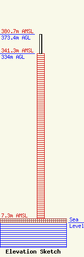
| Elevation Info |
Site Elevation: 7.3 meters (24 ft) |
| Height of Structure: 334 meters (1096 feet) |
| Overall Height Above Ground: 373.4 meters (1225 feet) |
| Overall Height Above Mean Sea Level: 380.7 meters (1249 feet) |
| Owner Info | WVEC Television, LLC
8401 Greensboro Drive
McLean, VA 22102
(703) 873-6600
lawdept@tegna.com |
| Contact Info | TEGNA Inc.
8401 Greensboro Drive
McLean, VA 22102
Denise Branson
(703) 873-6606
dbranson@tegna.com |
