|
|
Antenna Structure Registration 1043106 |
 |
Registration Info | Registration Number: 1043106 |
| File Number: A1297390 |
| FAA Study: 75-SO-1761-OE |
| FAA Issue Date: 12/08/1975 |
| Status: Constructed |
| Date Constructed: 05/01/1977 |
| FAA EMI: N |
| NEPA: N |
Structure Info
|
| Structure Coordinates: 37-53-14.2 N 87-31-7.0 W (NAD 83) |
| Structure Coordinates: 37-53-14.0 N 87-31-07.0 W (Converted to NAD 27) |
| Structure Address: On Wolf Hills 2300' Ne Of Int Of Wathen Ln & Cemetary Rd |
| Structure City: Henderson, KY |
| Structure County: Henderson County |
| Painting & Lighting Info |
FCC Paragraph(s): 1, 3, 7, 16, 21 |
Remarks: RED LIGHTS/PAINT |
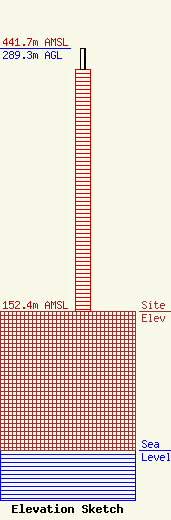
| Elevation Info |
Site Elevation: 152.4 meters (500 ft) |
| Height of Structure: 266.1 meters (873 feet) |
| Overall Height Above Ground: 289.3 meters (949 feet) |
| Overall Height Above Mean Sea Level: 441.7 meters (1449 feet) |
| Owner Info | Gray Local Media, Inc.
4370 Peachtree Road, NE
Atlanta, GA 30319
(404) 266-8333
legalnotices@graymedia.com |
| Contact Info | Gray Local Media, Inc.
4370 Peachtree Road NE
Atlanta, GA 30319
Engineering Department
(404) 266-8333
legalnotices@graymedia.com |
