|
|
Antenna Structure Registration 1043118 |
 |
Registration Info | Registration Number: 1043118 |
| File Number: A1388411 |
| FAA Study: 2026-ASO-6831-OE |
| FAA Issue Date: 06/11/2026 |
| Status: Constructed |
| Date Constructed: 07/01/1989 |
| NEPA: N |
Structure Info
| Structure Type: GTOWER |
| Structure Coordinates: 37-4-38.9 N 84-40-37.2 W (NAD 83) |
| Structure Coordinates: 37-04-38.6 N 84-40-37.4 W (Converted to NAD 27) |
| Structure Address: 3915 W Hwy 1248 Ky-5011 |
| Structure City: Somerset, KY |
| Structure County: Pulaski County |
| Painting & Lighting Info |
FCC Paragraph(s): A1, H, 3, 11, 21, 23 |
Remarks: PRIOR STUDY 2015-ASO-12881-OE |
Remarks: Continue As Is OM&L = A MED-DUAL SYSTEM |
Remarks: PRIOR STUDY 2015-ASO-12881-OE |
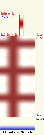
| Elevation Info |
Site Elevation: 310.3 meters (1018 ft) |
| Height of Structure: 81.6 meters (268 feet) |
| Overall Height Above Ground: 81.7 meters (268 feet) |
| Overall Height Above Mean Sea Level: 392 meters (1286 feet) |
| Owner Info | Vertical Bridge CC FM, LLC
22 W Atlantic Avenue
Delray Beach, FL 33444
(561) 406-4015
fcc-faa@verticalbridge.com |
| Contact Info | Vertical Bridge CC FM, LLC
22 W Atlantic Avenue
Delray Beach, FL 33444
Richard Hickey
(561) 406-4015
fcc-faa@verticalbridge.com |
