|
|
Antenna Structure Registration 1043436 |
 |
Registration Info | Registration Number: 1043436 |
| File Number: A1313153 |
| FAA Study: 2021-ASW-17735-OE |
| FAA Issue Date: 09/13/2022 |
| Status: Constructed |
| Date Constructed: 08/15/2011 |
| NEPA: N |
Structure Info
| Structure Type: GTOWER |
| Structure Coordinates: 34-55-53.9 N 92-31-12.2 W (NAD 83) |
| Structure Coordinates: 34-55-53.6 N 92-31-11.6 W (Converted to NAD 27) |
| Structure Address: 32224 Micro Wave Tower (88770) |
| Structure City: Roland, AR |
| Structure County: Pulaski County |
| Painting & Lighting Info |
FAA Circular #: 70/7460-1J |
FAA Chapters: 4, 6, 13 |
Remarks: PRIOR STUDY 2011-ASW-5155-OE |
Remarks: OM&L to remain the same as prior study = 24-HR MED-STROBES |
Remarks: PRIOR STUDY 2011-ASW-5155-OE |
| Elevation Info |
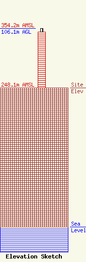
Site Elevation: 248.1 meters (814 ft) |
| Height of Structure: 99.7 meters (327 feet) |
| Overall Height Above Ground: 106.1 meters (348 feet) |
| Overall Height Above Mean Sea Level: 354.2 meters (1162 feet) |
| Owner Info | American Towers LLC
10 Presidential Way
01801
Woburn, MA 01801
(781) 926-4500
faa-fcc@americantower.com |
| Contact Info | American Towers LLC
10 Presidential Way
01801
Woburn, MA 01801
(781) 926-4500
faa-fcc@americantower.com |
