|
|
Antenna Structure Registration 1043701 |
 |
Registration Info | Registration Number: 1043701 |
| File Number: A0694158 |
| FAA Study: 02-AGL-446-OE |
| Status: Dismantled |
| Date Constructed: 03/05/2002 |
| FAA EMI: N |
| NEPA: N |
Structure Info
| Structure Type: TOWER |
| Structure Coordinates: 41-18-44.0 N 90-22-45.0 W (NAD 83) |
| Structure Coordinates: 41-18-43.9 N 90-22-44.5 W (Converted to NAD 27) |
| Structure Address: 2.8 Miles South |
| Structure City: Orion, IL |
| Structure County: Henry County |
| Painting & Lighting Info |
FAA Chapters: NONE |
| Elevation Info |
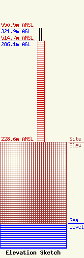
Site Elevation: 228.6 meters (750 ft) |
| Height of Structure: 286.1 meters (939 feet) |
| Overall Height Above Ground: 321.9 meters (1056 feet) |
| Overall Height Above Mean Sea Level: 550.5 meters (1806 feet) |
| Owner Info | Local TV Illinois, LLC
201 Main Street Suite 1620
Fort Worth, TX 76102
(817) 390-8503
|
| Contact Info | Dow Lohnes PLLC
1200 New Hampshire Ave, NWSuite 800
Washington, DC 20036
Kevin Latek
(202) 776-2000
klatek@dowlohnes.com |
