|
|
Antenna Structure Registration 1043705 |
 |
Registration Info | Registration Number: 1043705 |
| File Number: A1308771 |
| FAA Study: 94-AEA-2010-OE |
| Status: Constructed |
| Date Constructed: 06/01/1954 |
| FAA EMI: N |
| NEPA: N |
Structure Info
| Structure Type: TOWER |
| Structure Coordinates: 36-48-57.0 N 76-27-59.0 W (NAD 83) |
| Structure Coordinates: 36-48-56.5 N 76-28-00.2 W (Converted to NAD 27) |
| Structure Address: 5277 Nansemond Parkway |
| Structure City: Suffolk, VA |
| Structure County: Suffolk city |
| Painting & Lighting Info |
FAA Circular #: 70/7460-1H |
FAA Chapters: 3, 4, 5, 13 |
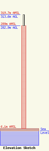
| Elevation Info |
Site Elevation: 6.1 meters (20 ft) |
| Height of Structure: 282.9 meters (928 feet) |
| Overall Height Above Ground: 313.6 meters (1029 feet) |
| Overall Height Above Mean Sea Level: 319.7 meters (1049 feet) |
| Owner Info | K2 Towers III, LLC
57 E Washington Street
Chagrin Falls, OH 44022
(440) 528-0333
rlepene@k2towers.com |
| Contact Info | K2 Towers III, LLC
57 E Washington Street
Chagrin Falls, OH 44022
Greg Thompson
(440) 528-0333
gthompson@k2towers.com |
