|
|
Antenna Structure Registration 1043709 |
 |
Registration Info | Registration Number: 1043709 |
| File Number: A1380988 |
| FAA Study: SW-OE-5019 |
| FAA Issue Date: 07/06/1965 |
| Status: Constructed |
| Date Constructed: 10/25/1985 |
| FAA EMI: N |
| NEPA: N |
Structure Info
| Structure Type: TOWER |
| Structure Coordinates: 35-30-43.0 N 94-21-39.0 W (NAD 83) |
| Structure Coordinates: 35-30-42.7 N 94-21-38.2 W (Converted to NAD 27) |
| Structure Address: 0.6 Mi Sw |
| Structure City: Figure Five, AR |
| Structure County: Crawford County |
| Painting & Lighting Info |
FCC Paragraph(s): 1, 3, 8, 17, 21 |
Remarks: RED LIGHTS/PAINT |
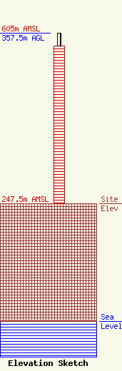
| Elevation Info |
Site Elevation: 247.5 meters (812 ft) |
| Height of Structure: 331 meters (1086 feet) |
| Overall Height Above Ground: 357.5 meters (1173 feet) |
| Overall Height Above Mean Sea Level: 605 meters (1985 feet) |
| Owner Info | Cape Publications, Inc.
8401 Greensboro Drive
McLean, VA 22102
(703) 873-6600
lawdept@tegna.com |
| Contact Info | TEGNA Inc.
8401 Greensboro Drive
McLean, VA 22102
Denise Branson
(703) 873-6606
dbranson@tegna.com |
