|
|
Antenna Structure Registration 1044020 |
 |
Registration Info | Registration Number: 1044020 |
| File Number: A0051775 |
| Status: Constructed |
| Date Constructed: 01/01/1968 |
| NEPA: N |
Structure Info
| Structure Type: TOWER |
| Structure Coordinates: 37-11-35.0 N 83-11-17.0 W (NAD 83) |
| Structure Coordinates: 37-11-34.7 N 83-11-17.4 W (Converted to NAD 27) |
| Structure Address: State Hwy 1096 5.8 Km S |
| Structure City: Hazard, KY |
| Structure County: Perry County |
| Painting & Lighting Info |
FCC Paragraph(s): 1, 3, 5, 14, 21 |
| Elevation Info |
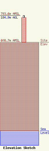
Site Elevation: 608.7 meters (1997 ft) |
| Height of Structure: 170.5 meters (559 feet) |
| Overall Height Above Ground: 184.9 meters (607 feet) |
| Overall Height Above Mean Sea Level: 793.6 meters (2604 feet) |
| Owner Info | KENTUCKY AUTHORITY FOR EDUCATIONAL TELEVISION DBA = WKHA
600 COOPER DR
LEXINGTON, KY 40502-2296
(606) 258-7172
STALBERT@KET.ORG |
