|
|
Antenna Structure Registration 1044021 |
 |
Registration Info | Registration Number: 1044021 |
| File Number: A0051776 |
| FAA Study: 98-ASO-3138-OE |
| FAA Issue Date: 06/25/1998 |
| Status: Constructed |
| Date Constructed: 01/01/1968 |
| NEPA: N |
Structure Info
| Structure Type: TOWER |
| Structure Coordinates: 37-11-21.0 N 87-30-49.0 W (NAD 83) |
| Structure Coordinates: 37-11-20.8 N 87-30-49.0 W (Converted to NAD 27) |
| Structure Address: 3.9 Km S Saint Charles Ky |
| Structure City: Madisonville, KY |
| Structure County: Hopkins County |
| Painting & Lighting Info |
FCC Paragraph(s): 1, 3, 7, 16, 21 |
Remarks: REF. 66-CLE-0236-OE NOS 18-0214. AEC |
| Elevation Info |
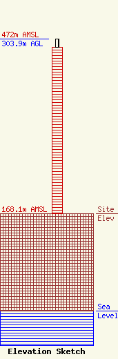
Site Elevation: 168.1 meters (552 ft) |
| Height of Structure: 289.3 meters (949 feet) |
| Overall Height Above Ground: 303.9 meters (997 feet) |
| Overall Height Above Mean Sea Level: 472 meters (1549 feet) |
| Owner Info | KENTUCKY AUTHORITY FOR EDUCATIONAL TELEVISION DBA = WKMA TV
600 COOPER DR
LEXINGTON, KY 40502-2296
(606) 258-7172
STALBERT@KET.ORG |
