|
|
Antenna Structure Registration 1044037 |
 |
Registration Info | Registration Number: 1044037 |
| File Number: A1140766 |
| FAA Study: 2017-ASO-22088-OE |
| FAA Issue Date: 08/03/2018 |
| Status: Constructed |
| Date Constructed: 04/24/2019 |
| NEPA: N |
Structure Info
| Structure Type: GTOWER |
| Structure Coordinates: 37-5-40.0 N 88-40-20.0 W (NAD 83) |
| Structure Coordinates: 37-05-39.8 N 88-40-19.8 W (Converted to NAD 27) |
| Structure Address: Coleman Rd |
| Structure City: Paducah, KY |
| Structure County: McCracken County |
| Painting & Lighting Info |
FAA Circular #: 70/7460-1L |
FAA Chapters: 4, 8, 12 |
Remarks: Removed expiration date from determination. Scenario 1./jjs/case#635066 |
Remarks: PRIOR STUDY 2003-ASO-55-OE |
Remarks: Removed expiration date from determination. Scenario 1./jjs/case#635066 |
Remarks: PRIOR STUDY 2003-ASO-55-OE |
| Elevation Info |
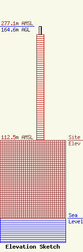
Site Elevation: 112.5 meters (369 ft) |
| Height of Structure: 152.2 meters (499 feet) |
| Overall Height Above Ground: 164.6 meters (540 feet) |
| Overall Height Above Mean Sea Level: 277.1 meters (909 feet) |
| Owner Info | KENTUCKY AUTHORITY FOR EDUCATIONAL TELEVISION DBA WKPD
600 COOPER DR
LEXINGTON, KY 40502-2296
(859) 258-7000
SHOPKINS@KET.ORG |
| Contact Info | KENTUCKY AUTHORITY FOR EDUCATIONAL TELEVISION DBA WKPD
600 COOPER DR
LEXINGTON, KY 40502-2296
(859) 258-7000
CHARPER@KET.ORG |
