|
|
Antenna Structure Registration 1044038 |
 |
Registration Info | Registration Number: 1044038 |
| File Number: A0269676 |
| FAA Study: 00-ASO-6257-OE |
| FAA Issue Date: 09/28/2000 |
| Status: Constructed |
| Date Constructed: 06/13/2002 |
| FAA EMI: Y |
| NEPA: N |
Structure Info
| Structure Type: TOWER |
| Structure Coordinates: 37-51-7.0 N 87-19-44.0 W (NAD 83) |
| Structure Coordinates: 37-51-06.8 N 87-19-44.0 W (Converted to NAD 27) |
| Structure Address: Off Hwy 60, 2 Mi E |
| Structure City: Henderson, KY |
| Structure County: Henderson County |
| Painting & Lighting Info |
FAA Circular #: 70/7460-1K |
FAA Chapters: 4, 8, 12 |
Remarks: PRIOR FAA 76-SO-2163-OE |
| Elevation Info |
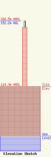
Site Elevation: 114.3 meters (375 ft) |
| Height of Structure: 137.1 meters (450 feet) |
| Overall Height Above Ground: 152.2 meters (499 feet) |
| Overall Height Above Mean Sea Level: 266.5 meters (874 feet) |
| Owner Info | KENTUCKY AUTHORITY FOR EDUCATIONAL TELEVISION DBA = WKOH
600 COOPER DR
LEXINGTON, KY 40502-2296
(606) 258-7172
STALBERT@KET.ORG |
