|
|
Antenna Structure Registration 1044045 |
 |
Registration Info | Registration Number: 1044045 |
| File Number: A0051801 |
| Status: Constructed |
| Date Constructed: 01/01/1968 |
| NEPA: N |
Structure Info
| Structure Type: TOWER |
| Structure Coordinates: 37-17-6.0 N 82-31-28.0 W (NAD 83) |
| Structure Coordinates: 37-17-05.6 N 82-31-28.4 W (Converted to NAD 27) |
| Structure Address: Flatwoods Mountain 4.8 Km Ne Of Dorton Ky |
| Structure City: Pikeville, KY |
| Structure County: Pike County |
| Painting & Lighting Info |
FCC Paragraph(s): None |
| Elevation Info |
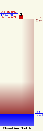
Site Elevation: 863.5 meters (2833 ft) |
| Height of Structure: 30.7 meters (101 feet) |
| Overall Height Above Ground: 47.6 meters (156 feet) |
| Overall Height Above Mean Sea Level: 911.1 meters (2989 feet) |
| Owner Info | KENTUCKY AUTHORITY FOR EDUCATIONAL TELEVISION DBA = WKPI TV
600 COOPER DR
LEXINGTON, KY 40502-2296
(606) 258-7172
STALBERT@KET.ORG |
