|
|
Antenna Structure Registration 1044237 |
 |
Registration Info | Registration Number: 1044237 |
| File Number: A0804201 |
| FAA Study: 2012-AEA-4895-OE |
| FAA Issue Date: 11/30/2012 |
| Status: Constructed |
| Date Constructed: 01/01/1987 |
| FAA EMI: N |
| NEPA: N |
Structure Info
| Structure Type: GTOWER |
| Structure Coordinates: 39-20-10.4 N 76-38-57.9 W (NAD 83) |
| Structure Coordinates: 39-20-10.0 N 76-38-59.0 W (Converted to NAD 27) |
| Structure Address: 3900 Hooperave |
| Structure City: Baltimore, MD |
| Structure County: Baltimore city |
| Painting & Lighting Info |
FAA Circular #: 70/7460-1J |
FAA Chapters: 4, 7, 13 |
Remarks: PRIOR STUDY 1997-AEA-3845-OE |
Remarks: OM&L to remain the same as prior study = 24-HR HI-STROBES |
Remarks: PRIOR STUDY 1997-AEA-3845-OE |
Remarks: OM&L to remain the same as prior study = 24-HR HI-STROBES |
| Elevation Info |
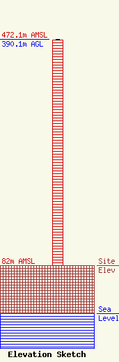
Site Elevation: 82 meters (269 ft) |
| Height of Structure: 389.2 meters (1277 feet) |
| Overall Height Above Ground: 390.1 meters (1280 feet) |
| Overall Height Above Mean Sea Level: 472.1 meters (1549 feet) |
| Owner Info | CUNNINGHAM COMMUNICATIONS, INC
10706 Beaver Dam Road
Cockeysville, MD 21030
(410) 568-1500
dusmith@sbgtv.com |
| Contact Info | Carl T. Jones Corporation
7901 Yarnwood Ct.
Springfield, VA 22153
(703) 569-7704
wgetz@ctjc.com |
