|
|
Antenna Structure Registration 1044553 |
 |
Registration Info | Registration Number: 1044553 |
| File Number: A1138698 |
| FAA Study: 91-ASO-1521-OE |
| FAA Issue Date: 11/13/1991 |
| Status: Constructed |
| Date Constructed: 01/01/1992 |
| NEPA: N |
Structure Info
| Structure Type: TOWER |
| Structure Coordinates: 37-27-57.0 N 82-33-4.0 W (NAD 83) |
| Structure Coordinates: 37-27-56.6 N 82-33-04.4 W (Converted to NAD 27) |
| Structure Address: 2 Km Sw |
| Structure City: Pikeville, KY |
| Structure County: Pike County |
| Painting & Lighting Info |
FCC Paragraph(s): 1, 3, 4, 13, 21 |
Remarks: RED LIGHTS/PAINT |
| Elevation Info |
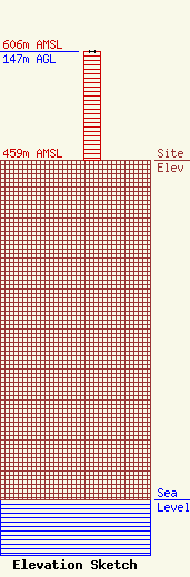
Site Elevation: 459 meters (1506 ft) |
| Height of Structure: 146 meters (479 feet) |
| Overall Height Above Ground: 147 meters (482 feet) |
| Overall Height Above Mean Sea Level: 606 meters (1988 feet) |
| Owner Info | Mountain Top Media LLC
P.O. Box 2040
Pikeville, KY 41502
(606) 437-4051
cindy@mountain-topmedia.com |
| Contact Info | Mountain Top Media LLC
P.O. Box 2040
Pikeville, KY 41502
Cindy Johnson
(606) 437-4051
cindy@mountain-topmedia.com |
