|
|
Antenna Structure Registration 1044762 |
 |
Registration Info | Registration Number: 1044762 |
| File Number: A0355349 |
| FAA Study: 80-AEA-899-OE |
| FAA Issue Date: 11/04/1983 |
| Status: Constructed |
| Date Constructed: 03/15/1984 |
| FAA EMI: N |
| NEPA: N |
Structure Info
| Structure Type: TOWER |
| Structure Coordinates: 39-38-24.0 N 74-17-31.0 W (NAD 83) |
| Structure Coordinates: 39-38-23.6 N 74-17-32.5 W (Converted to NAD 27) |
| Structure Address: End Of Murphy Dr 1/2 Mi Off Us Hwy 9 |
| Structure City: West Creek, NJ |
| Structure County: Ocean County |
| Painting & Lighting Info |
FCC Paragraph(s): 1, 3, 11, 21 |
Remarks: RED LIGHTS/PAINT |
| Elevation Info |
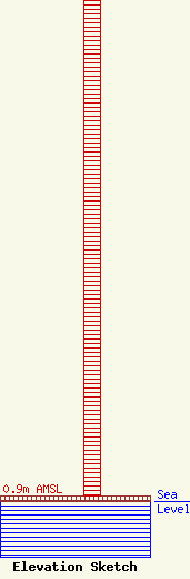
Site Elevation: 0.9 meters (3 ft) |
| Height of Structure: 91.4 meters (300 feet) |
| Overall Height Above Ground: 91.4 meters (300 feet) |
| Overall Height Above Mean Sea Level: 92.3 meters (303 feet) |
| Owner Info | WYRS Broadcasting
730
Manahawkin, NJ 08050
(609) 978-1678
bob@wyrs.org |
| Contact Info | WYRS Broadcasting
730
Manahawkin, NJ 08050
Robert Wick
(609) 978-1678
bob@wyrs.org |
