|
|
Antenna Structure Registration 1044830 |
 |
Registration Info | Registration Number: 1044830 |
| File Number: A0715308 |
| FAA Study: 2007-ASO-488-OE |
| FAA Issue Date: 03/05/2007 |
| Status: Constructed |
| Date Constructed: 02/14/2011 |
| FAA EMI: N |
| NEPA: N |
Structure Info
| Structure Type: TOWER |
| Structure Coordinates: 37-10-35.2 N 85-55-24.7 W (NAD 83) |
| Structure Coordinates: 37-10-35.0 N 85-55-24.8 W (Converted to NAD 27) |
| Structure Address: Vial Knob Road |
| Structure City: Horsecave, KY |
| Structure County: Hart County |
| Painting & Lighting Info |
FCC Paragraph(s): 1, 3, 11, 21 |
Remarks: Continue As Is OM&L = PAINT/RED LIGHTS |
Remarks: PRIOR STUDY 1977-ASO-176-OE |
| Elevation Info |
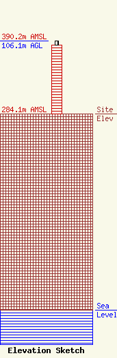
Site Elevation: 284.1 meters (932 ft) |
| Height of Structure: 100.6 meters (330 feet) |
| Overall Height Above Ground: 106.1 meters (348 feet) |
| Overall Height Above Mean Sea Level: 390.2 meters (1280 feet) |
| Owner Info | KENTUCKY, COMMONWEALTH OF DBA = KY EMERGENCY WARNING SYSTEM KEWS
100 Minuteman Pky Building 101
Frankfort, KY 40601
(502) 564-5397
william.hays@ky.gov |
