|
|
Antenna Structure Registration 1045046 |
 |
Registration Info | Registration Number: 1045046 |
| File Number: A0559656 |
| FAA Study: 97-AEA-2838-OE |
| FAA Issue Date: 09/19/1997 |
| Status: Terminated |
| Date Constructed: 05/29/1997 |
| FAA EMI: N |
| NEPA: N |
Structure Info
| Structure Type: BANT |
| Structure Coordinates: 40-13-43.0 N 73-59-54.0 W (NAD 83) |
| Structure Coordinates: 40-13-42.6 N 73-59-55.5 W (Converted to NAD 27) |
| Structure Address: 1701 Ocean Ave |
| Structure City: Asbury Park, NJ |
| Structure County: Monmouth County |
| Painting & Lighting Info |
FAA Circular #: 70/7460-1J |
FAA Chapters: 3, 4, 5, 13 |
| Elevation Info |
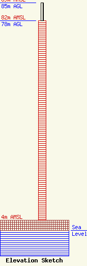
Site Elevation: 4 meters (13 ft) |
| Height of Structure: 78 meters (256 feet) |
| Overall Height Above Ground: 85 meters (279 feet) |
| Overall Height Above Mean Sea Level: 89 meters (292 feet) |
| Owner Info | Pinnacle Towers LLC
2000 Corporate Drive
Canonsburg, PA 15317
(724) 416-2000
regulatory.department@crowncastle.com |
| Info |
