|
|
Antenna Structure Registration 1045220 |
 |
Registration Info | Registration Number: 1045220 |
| File Number: A1135107 |
| FAA Study: 2018-ASO-10151-OE |
| FAA Issue Date: 06/18/2018 |
| Status: Constructed |
| Date Constructed: 01/01/1988 |
| NEPA: N |
Structure Info
| Structure Type: GTOWER |
| Structure Coordinates: 33-26-34.5 N 79-8-24.1 W (NAD 83) |
| Structure Coordinates: 33-26-33.9 N 79-08-24.9 W (Converted to NAD 27) |
| Structure Address: 715 Grate Ave (sc12280-a Tower #2) |
| Structure City: Pawley's Island, SC |
| Structure County: Georgetown County |
| Painting & Lighting Info |
FAA Circular #: 70/7460-1L |
FAA Chapters: 4, 8, 12 |
Remarks: PRIOR STUDY 2010-ASO-239-OE |
| Elevation Info |
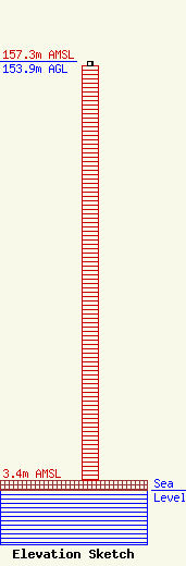
Site Elevation: 3.4 meters (11 ft) |
| Height of Structure: 152.4 meters (500 feet) |
| Overall Height Above Ground: 153.9 meters (505 feet) |
| Overall Height Above Mean Sea Level: 157.3 meters (516 feet) |
| Owner Info | SBA Towers II LLC
8051 Congress Avenue
Boca Raton, FL 33487
(561) 995-7670
ERoach@sbasite.com |
| Contact Info | SBA Towers II LLC
8051 Congress Avenue
Boca Raton, FL 33487
(561) 995-7670
ERoach@sbasite.com |
