|
|
Antenna Structure Registration 1045351 |
 |
Registration Info | Registration Number: 1045351 |
| File Number: A1070800 |
| FAA Study: 2016-ASO-6530-OE |
| FAA Issue Date: 03/22/2016 |
| Status: Constructed |
| Date Constructed: 06/24/2016 |
| NEPA: N |
Structure Info
| Structure Type: GTOWER |
| Structure Coordinates: 35-44-12.0 N 80-38-51.0 W (NAD 83) |
| Structure Coordinates: 35-44-11.5 N 80-38-51.8 W (Converted to NAD 27) |
| Structure Address: Off Old Highway 70 Near Clevland (#274805) |
| Structure City: Clevland, NC |
| Structure County: Rowan County |
| Painting & Lighting Info |
FAA Circular #: 70/7460-1L |
FAA Chapters: 4, 8, 12 |
Remarks: PRIOR STUDY 2013-ASO-1367-OE |
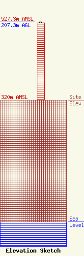
| Elevation Info |
Site Elevation: 320 meters (1050 ft) |
| Height of Structure: 204.8 meters (672 feet) |
| Overall Height Above Ground: 207.3 meters (680 feet) |
| Overall Height Above Mean Sea Level: 527.3 meters (1730 feet) |
| Owner Info | American Towers LLC
10 Presidential Way
Woburn, MA 01801
(678) 564-3236
faa-fcc@americantower.com |
| Contact Info | American Towers, LLC.
10 Presidential Way
Woburn, MA 01801
(678) 564-3236
faa-fcc@americantower.com |
