|
|
Antenna Structure Registration 1045844 |
 |
Registration Info | Registration Number: 1045844 |
| File Number: A1318035 |
| FAA Study: 70-EA-427-OE |
| FAA Issue Date: 06/16/1971 |
| Status: Constructed |
| Date Constructed: 01/01/1970 |
| FAA EMI: N |
| NEPA: N |
Structure Info
| Structure Type: TOWER |
| Structure Coordinates: 41-0-41.0 N 74-18-3.0 W (NAD 83) |
| Structure Coordinates: 41-00-40.6 N 74-18-04.5 W (Converted to NAD 27) |
| Structure Address: Federal Hill |
| Structure City: Pompton Lakes, NJ |
| Structure County: Passaic County |
| Painting & Lighting Info |
FCC Paragraph(s): 1, 3, 4, 13, 21 |
Remarks: RED LIGHTS/PAINT |
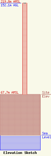
| Elevation Info |
Site Elevation: 67.7 meters (222 ft) |
| Height of Structure: 152.1 meters (499 feet) |
| Overall Height Above Ground: 152.1 meters (499 feet) |
| Overall Height Above Mean Sea Level: 219.8 meters (721 feet) |
| Owner Info | GTC Uno, LLC
PO Box 2359
Ponte Vedra Beach, FL 32004
(844) 482-8977
regulatory@gtctowers.com |
| Contact Info | GTC Uno, LLC
PO Box 2359
Ponte Vedra Beach, FL 32004
Clarence Cook
(844) 482-8977
regulatory@gtctowers.com |
