|
|
Antenna Structure Registration 1047057 |
 |
Registration Info | Registration Number: 1047057 |
| File Number: A0055364 |
| FAA Study: 82-ASW-2593-OE |
| FAA Issue Date: 11/16/1983 |
| Status: Constructed |
| Date Constructed: 06/18/1983 |
| NEPA: N |
Structure Info
| Structure Type: TOWER |
| Structure Coordinates: 32-46-56.0 N 96-46-32.0 W (NAD 83) |
| Structure Coordinates: 32-46-55.5 N 96-46-31.0 W (Converted to NAD 27) |
| Structure Address: 3131 Dawson |
| Structure City: Dallas, TX |
| Structure County: Dallas County |
| Painting & Lighting Info |
FCC Paragraph(s): 1, 3, 4, 13, 21 |
Remarks: RED LIGHTS/PAINT |
| Elevation Info |
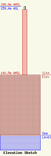
Site Elevation: 140.5 meters (461 ft) |
| Height of Structure: 152.4 meters (500 feet) |
| Overall Height Above Ground: 159.4 meters (523 feet) |
| Overall Height Above Mean Sea Level: 299.9 meters (984 feet) |
| Owner Info | DALLAS, CITY OF
3131 DAWSON ST
DALLAS, TX 75226
(214) 670-7995
DSCRIVNR@BIGTEX.CI.DALLAS.TX.US |
