|
|
Antenna Structure Registration 1047144 |
 |
Registration Info | Registration Number: 1047144 |
| File Number: A1069203 |
| FAA Study: 2011-ASW-3137-OE |
| FAA Issue Date: 07/15/2011 |
| Status: Dismantled |
| Date Constructed: 05/04/2009 |
| FAA EMI: N |
| NEPA: N |
Structure Info
|
| Structure Coordinates: 32-36-3.2 N 94-52-9.6 W (NAD 83) |
| Structure Coordinates: 32-36-02.7 N 94-52-08.8 W (Converted to NAD 27) |
| Structure Address: 841 Robin Lane (090289) |
| Structure City: Gladewater, TX |
| Structure County: Upshur County |
| Painting & Lighting Info |
FAA Circular #: 70/7460-1K |
FAA Chapters: 4, 7, 12 |
Remarks: PRIOR STUDY 2009-ASW-1585-OE |
Remarks: OM&L to remain the same as prior study = 24-HR HI-STROBES |
Remarks: PRIOR STUDY 2009-ASW-1585-OE |
Remarks: OM&L to remain the same as prior study = 24-HR HI-STROBES |
| Elevation Info |
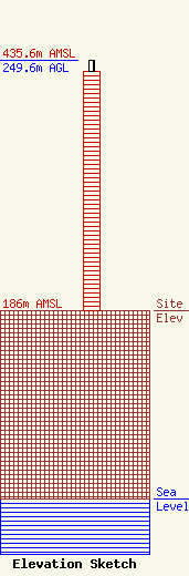
Site Elevation: 186 meters (610 ft) |
| Height of Structure: 238.6 meters (783 feet) |
| Overall Height Above Ground: 249.6 meters (819 feet) |
| Overall Height Above Mean Sea Level: 435.6 meters (1429 feet) |
| Owner Info | American Towers, LLC.
10 Presidential Way
Woburn, MA 01801
(781) 926-4500
faa-fcc@americantower.com |
| Contact Info | American Towers, LLC.
10 Presidential Way
Woburn, MA 01801
(781) 926-4500
faa-fcc@americantower.com |
