|
|
Antenna Structure Registration 1047305 |
 |
Registration Info | Registration Number: 1047305 |
| File Number: A1151553 |
| FAA Study: 70-HOU-440-OE |
| FAA Issue Date: 08/31/1970 |
| Status: Dismantled |
| Date Constructed: 01/01/1970 |
| NEPA: N |
Structure Info
|
| Structure Coordinates: 30-47-22.0 N 96-43-13.0 W (NAD 83) |
| Structure Coordinates: 30-47-21.3 N 96-43-12.1 W (Converted to NAD 27) |
| Structure Address: 900 Ft N Of Us Hwy 79 |
| Structure City: Gause, TX |
| Structure County: Milam County |
| Painting & Lighting Info |
FCC Paragraph(s): 1, 3, 11, 21 |
Remarks: RED LIGHTS/PAINT |
| Elevation Info |
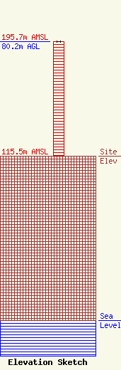
Site Elevation: 115.5 meters (379 ft) |
| Height of Structure: 80.2 meters (263 feet) |
| Overall Height Above Ground: 80.2 meters (263 feet) |
| Overall Height Above Mean Sea Level: 195.7 meters (642 feet) |
| Owner Info | LSB Broadcasting, Inc.
8350 Broad Street, Suite 2000
Tysons, VA 22102
(703) 873-6902
mbeder@TEGNA.com |
| Contact Info | LSB Broadcasting, Inc.
8350 Broad Street, Suite 2000
Tysons, VA 22102
Denise Branson
(703) 873-6606
dbranson@TEGNA.com |
