|
|
Antenna Structure Registration 1047306 |
 |
Registration Info | Registration Number: 1047306 |
| File Number: A1381256 |
| FAA Study: 79-ASW-1374-OE |
| FAA Issue Date: 11/02/1979 |
| Status: Constructed |
| Date Constructed: 09/01/1981 |
| NEPA: N |
Structure Info
| Structure Type: TOWER |
| Structure Coordinates: 31-16-25.0 N 97-13-15.0 W (NAD 83) |
| Structure Coordinates: 31-16-24.4 N 97-13-14.0 W (Converted to NAD 27) |
| Structure Address: 2.4 Mi Se Of I-h35 On Old Blevins Rd Exit 314 |
| Structure City: Eddy, TX |
| Structure County: Falls County |
| Painting & Lighting Info |
FCC Paragraph(s): A1, B, F, H |
Remarks: HIGH INTENSITY WHITE LIGHTS |
| Elevation Info |
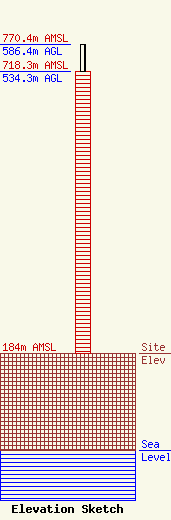
Site Elevation: 184 meters (604 ft) |
| Height of Structure: 534.3 meters (1753 feet) |
| Overall Height Above Ground: 586.4 meters (1924 feet) |
| Overall Height Above Mean Sea Level: 770.4 meters (2528 feet) |
| Owner Info | LSB Broadcasting, Inc.
8401 Greensboro Drive
McLean, VA 22102
(703) 873-6600
lawdept@tegna.com |
| Contact Info | TEGNA Inc.
8401 Greensboro Drive
McLean, VA 22102
Denise Branson
(703) 873-6606
dbranson@tegna.com |
