|
|
Antenna Structure Registration 1047310 |
 |
Registration Info | Registration Number: 1047310 |
| File Number: A1143861 |
| FAA Study: 2009-ASW-5076-OE |
| FAA Issue Date: 11/24/2009 |
| Status: Constructed |
| Date Constructed: 01/01/1968 |
| FAA EMI: N |
| NEPA: N |
Structure Info
| Structure Type: TOWER |
| Structure Coordinates: 33-30-8.0 N 101-52-22.0 W (NAD 83) |
| Structure Coordinates: 33-30-07.7 N 101-52-20.4 W (Converted to NAD 27) |
| Structure Address: 100th And University Ave |
| Structure City: Lubbock, TX |
| Structure County: Lubbock County |
| Painting & Lighting Info |
FAA Chapters: NONE |
Remarks: PRIOR STUDY 2004-ASW-6803-OE |
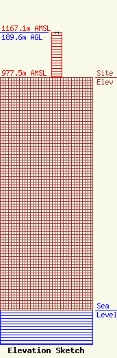
| Elevation Info |
Site Elevation: 977.5 meters (3207 ft) |
| Height of Structure: 189.6 meters (622 feet) |
| Overall Height Above Ground: 189.6 meters (622 feet) |
| Overall Height Above Mean Sea Level: 1167.1 meters (3829 feet) |
| Owner Info | FLP Ramar, Ltd.
3757
Lubbock, TX 79452
(806) 748-9300
bmoran@ramarcom.com |
| Contact Info | Telecommunications Law Professionals PLLC
1025 Connecticut Ave, NW
Washington, DC 20036
Dennis Corbett
(202) 789-3115
dcorbett@telecomlawpros.com |
