|
|
Antenna Structure Registration 1047348 |
 |
Registration Info | Registration Number: 1047348 |
| File Number: A0055716 |
| FAA Study: 83-ASW-0989-OE |
| Status: Constructed |
| Date Constructed: 03/08/1985 |
| NEPA: N |
Structure Info
| Structure Type: TOWER |
| Structure Coordinates: 29-34-7.0 N 95-29-58.0 W (NAD 83) |
| Structure Coordinates: 29-34-06.2 N 95-29-57.2 W (Converted to NAD 27) |
| Structure Address: 4126 Farm To Market Rd 2234 |
| Structure City: Missouri City, TX |
| Structure County: Fort Bend County |
| Painting & Lighting Info |
FAA Circular #: 70/7460-1F |
FAA Chapters: 4, 6, 9 |
| Elevation Info |
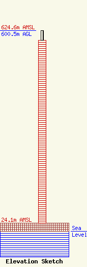
Site Elevation: 24.1 meters (79 ft) |
| Height of Structure: 569.8 meters (1869 feet) |
| Overall Height Above Ground: 600.5 meters (1970 feet) |
| Overall Height Above Mean Sea Level: 624.5 meters (2049 feet) |
| Owner Info | HOUSTON TOWER JOINT VENTURE
8181 SW FREEWAY
HOUSTON, TX 77074
(713) 778-4885
DWERNER@KPRC.COM |
