|
|
Antenna Structure Registration 1047596 |
 |
Registration Info | Registration Number: 1047596 |
| File Number: A0463362 |
| Status: Constructed |
| Date Constructed: 01/01/1956 |
| FAA EMI: N |
| NEPA: N |
Structure Info
| Structure Type: TOWER |
| Structure Coordinates: 42-4-37.0 N 77-55-46.0 W (NAD 83) |
| Structure Coordinates: 42-04-36.8 N 77-55-47.0 W (Converted to NAD 27) |
| Structure Address: 100 M Off Carter Rd .8 Km E Of Int W River Rd |
| Structure City: Wellsville, NY |
| Structure County: Allegany County |
| Painting & Lighting Info |
FCC Paragraph(s): 1, 3, 11, 21 |
| Elevation Info |
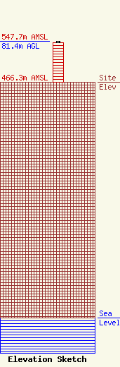
Site Elevation: 466.3 meters (1530 ft) |
| Height of Structure: 79.2 meters (260 feet) |
| Overall Height Above Ground: 81.4 meters (267 feet) |
| Overall Height Above Mean Sea Level: 547.7 meters (1797 feet) |
| Owner Info | DBM COMMUNICATIONS INC
82 RAILROAD AVE
WELLSVILLE, NY 14895
(585) 593-6070
WJQZ@adelphia.net |
| Contact Info | DBM COMMUNICATIONS INC
82 RAILROAD AVE
WELLSVILLE, NY 14895
RICHARD MANGELS
(585) 593-6070
rjmange@hotmail.com |
