|
|
Antenna Structure Registration 1047885 |
 |
Registration Info | Registration Number: 1047885 |
| File Number: A1305078 |
| FAA Study: 2024-AWP-13700-OE |
| FAA Issue Date: 12/03/2024 |
| Status: Constructed |
| Date Constructed: 04/26/2011 |
| NEPA: N |
Structure Info
| Structure Type: GTOWER |
| Structure Coordinates: 38-7-7.2 N 120-43-30.9 W (NAD 83) |
| Structure Coordinates: 38-07-07.5 N 120-43-27.1 W (Converted to NAD 27) |
| Structure Address: End Of Riata Way Bear Mountain (ca1899e-a) |
| Structure City: San Andreas, CA |
| Structure County: Calaveras County |
| Painting & Lighting Info |
FAA Circular #: 70/7460-1K |
FAA Chapters: 4, 8, 12 |
Remarks: OM&L to remain the same as prior study = A MED-DUAL SYSTEM |
Remarks: PRIOR STUDY 2001-AWP-2386-OE |
Remarks: OM&L to remain the same as prior study = A MED-DUAL SYSTEM |
Remarks: PRIOR STUDY 2001-AWP-2386-OE |
| Elevation Info |
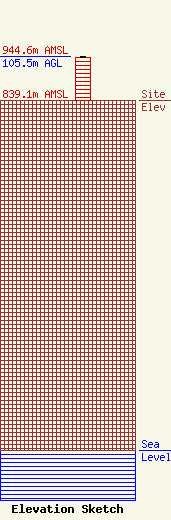
Site Elevation: 839.1 meters (2753 ft) |
| Height of Structure: 103.6 meters (340 feet) |
| Overall Height Above Ground: 105.5 meters (346 feet) |
| Overall Height Above Mean Sea Level: 944.6 meters (3099 feet) |
| Owner Info | SBA Towers XI, LLC
8051 Congress Avenue
Boca Raton, FL 33487
(561) 995-7670
ERoach@sbasite.com |
| Contact Info | SBA Towers XI, LLC
8051 Congress Avenue
Boca Raton, FL 33487
(561) 995-7670
ERoach@sbasite.com |
