|
|
Antenna Structure Registration 1048112 |
 |
Registration Info | Registration Number: 1048112 |
| File Number: A1116273 |
| FAA Study: 2017-AEA-13186-OE |
| FAA Issue Date: 01/08/2018 |
| Status: Constructed |
| Date Constructed: 01/01/1987 |
| NEPA: N |
Structure Info
| Structure Type: LTOWER |
| Structure Coordinates: 39-20-17.6 N 76-39-58.7 W (NAD 83) |
| Structure Coordinates: 39-20-17.2 N 76-39-59.8 W (Converted to NAD 27) |
| Structure Address: 4344 Park Heights Ave. (202607) |
| Structure City: Baltimore, MD |
| Structure County: Baltimore city |
| Painting & Lighting Info |
FAA Circular #: 70/7460-1L |
FAA Chapters: 4, 8, 12 |
Remarks: PRIOR STUDY 1998-AEA-1528-OE |
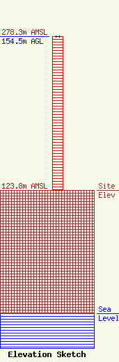
| Elevation Info |
Site Elevation: 123.8 meters (406 ft) |
| Height of Structure: 154.5 meters (507 feet) |
| Overall Height Above Ground: 154.5 meters (507 feet) |
| Overall Height Above Mean Sea Level: 278.3 meters (913 feet) |
| Owner Info | American Towers LLC
10 Presidential Way
Woburn, MA 01801
(781) 926-4500
faa-fcc@americantower.com |
| Contact Info | American Towers, LLC
10 Presidential Way
Woburn, MA 01801
(781) 926-4500
faa-fcc@americantower.com |
