|
|
Antenna Structure Registration 1049195 |
 |
Registration Info | Registration Number: 1049195 |
| File Number: A0057896 |
| FAA Study: 98-ACE-0542-OE |
| FAA Issue Date: 06/11/1998 |
| Status: Constructed |
| Date Constructed: 01/01/1993 |
| NEPA: N |
Structure Info
| Structure Type: TOWER |
| Structure Coordinates: 40-44-4.0 N 91-15-16.0 W (NAD 83) |
| Structure Coordinates: 40-44-03.9 N 91-15-15.5 W (Converted to NAD 27) |
| Structure Address: Rt 16 2.8 Mi W Of Hwy 61 |
| Structure City: Weaver, IA |
| Structure County: Lee County |
| Painting & Lighting Info |
FAA Circular #: 70/7460-1J |
FAA Chapters: 3, 4, 5, 13 |
| Elevation Info |
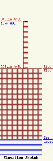
Site Elevation: 206.1 meters (676 ft) |
| Height of Structure: 136.5 meters (448 feet) |
| Overall Height Above Ground: 137 meters (449 feet) |
| Overall Height Above Mean Sea Level: 343.1 meters (1126 feet) |
| Owner Info | PRITCHARD BROADCASTING CO DBA = STATION KDMG
2850 MOUNT PLEASANT ST
BURLINGTON, IA 52601
(319) 752-5402
|
