|
|
Antenna Structure Registration 1049199 |
 |
Registration Info | Registration Number: 1049199 |
| File Number: A1243837 |
| FAA Study: 78-AEA-761-OE |
| FAA Issue Date: 09/14/1978 |
| Status: Constructed |
| Date Constructed: 10/03/2016 |
| NEPA: N |
Structure Info
| Structure Type: BTWR |
| Structure Coordinates: 40-23-2.0 N 75-21-1.0 W (NAD 83) |
| Structure Coordinates: 40-23-01.6 N 75-21-02.4 W (Converted to NAD 27) |
| Structure Address: 300 Ft W Of Tower Rd 4055 Ft S Of Berger Rd |
| Structure City: West Rockhill Townsh, PA |
| Structure County: Bucks County |
| Painting & Lighting Info |
FAA Chapters: NONE |
| Elevation Info |
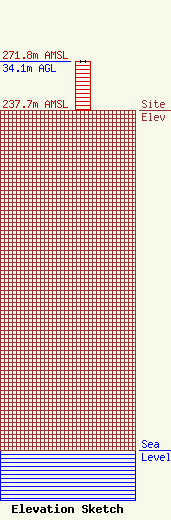
Site Elevation: 237.7 meters (780 ft) |
| Height of Structure: 34.1 meters (112 feet) |
| Overall Height Above Ground: 34.1 meters (112 feet) |
| Overall Height Above Mean Sea Level: 271.8 meters (892 feet) |
| Owner Info | Bucks County Emergency Communications
1265 Almshouse Rd
Doylestown, PA 18901
(215) 345-3280
mjjimison@buckscounty.org |
| Contact Info | Bucks County Emergency Communications
1265 Almshouse Rd
Doylestown, PA 18901
Michael Jimison
(215) 345-3280
mjjimison@buckscounty.org |
