|
|
Antenna Structure Registration 1049792 |
 |
Registration Info | Registration Number: 1049792 |
| File Number: A1297415 |
| FAA Study: 97-AEA-3987-OE |
| FAA Issue Date: 01/23/1998 |
| Status: Constructed |
| Date Constructed: 08/01/1984 |
| NEPA: N |
Structure Info
| Structure Type: TOWER |
| Structure Coordinates: 39-17-5.0 N 80-16-41.0 W (NAD 83) |
| Structure Coordinates: 39-17-04.7 N 80-16-41.7 W (Converted to NAD 27) |
| Structure Address: 5 Television Drive |
| Structure City: Bridgeport, WV |
| Structure County: Harrison County |
| Painting & Lighting Info |
FAA Circular #: 70/7460-1J |
FAA Chapters: 3, 4, 5, 13 |
| Elevation Info |
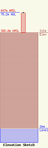
Site Elevation: 368.8 meters (1210 ft) |
| Height of Structure: 76.6 meters (251 feet) |
| Overall Height Above Ground: 78.2 meters (257 feet) |
| Overall Height Above Mean Sea Level: 447 meters (1467 feet) |
| Owner Info | Gray Local Media, Inc.
4370 Peachtree Road, NE
Atlanta, GA 30319
(404) 266-8333
legalnotices@graymedia.com |
| Contact Info | Gray Local Media, Inc.
4370 Peachtree Road NE
Atlanta, GA 30319
Engineering Department
(404) 266-8333
legalnotices@graymedia.com |
