|
|
Antenna Structure Registration 1050013 |
 |
Registration Info | Registration Number: 1050013 |
| File Number: A1317749 |
| FAA Study: 2025-ASW-6169-OE |
| FAA Issue Date: 06/25/2025 |
| Status: Constructed |
| Date Constructed: 07/18/2011 |
| NEPA: N |
Structure Info
| Structure Type: GTOWER |
| Structure Coordinates: 27-31-28.9 N 99-31-20.8 W (NAD 83) |
| Structure Coordinates: 27-31-27.8 N 99-31-19.6 W (Converted to NAD 27) |
| Structure Address: 2800 Anna Ave (laredo 4 #4552) |
| Structure City: Laredo, TX |
| Structure County: Webb County |
| Painting & Lighting Info |
FAA Circular #: 70/7460-1J |
FAA Chapters: 4, 8, 13 |
Remarks: OM&L to remain the same as prior study = A MED-DUAL SYSTEM |
Remarks: PRIOR STUDY 2011-ASW-3598-OE |
Remarks: OM&L to remain the same as prior study = A MED-DUAL SYSTEM |
Remarks: PRIOR STUDY 2011-ASW-3598-OE |
| Elevation Info |
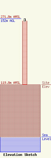
Site Elevation: 119.8 meters (393 ft) |
| Height of Structure: 146.3 meters (480 feet) |
| Overall Height Above Ground: 152 meters (499 feet) |
| Overall Height Above Mean Sea Level: 271.8 meters (892 feet) |
| Owner Info | American Towers LLC
10 Presidential Way
01801
Woburn, MA 01801
(781) 926-4500
faa-fcc@americantower.com |
| Contact Info | American Towers LLC
10 Presidential Way
01801
Woburn, MA 01801
(781) 926-4500
faa-fcc@americantower.com |
