|
|
Antenna Structure Registration 1050092 |
 |
Registration Info | Registration Number: 1050092 |
| File Number: A1157375 |
| FAA Study: 89-AGL-502-OE |
| FAA Issue Date: 05/09/1989 |
| Status: Constructed |
| Date Constructed: 06/01/1989 |
| NEPA: N |
Structure Info
| Structure Type: TOWER |
| Structure Coordinates: 44-45-38.0 N 88-30-40.0 W (NAD 83) |
| Structure Coordinates: 44-45-38.0 N 88-30-39.6 W (Converted to NAD 27) |
| Structure Address: 1200ft West Of Hillcrest Drive On Castle Road |
| Structure City: Shawano, WI |
| Structure County: Shawano County |
| Painting & Lighting Info |
FAA Chapters: NONE |
| Elevation Info |
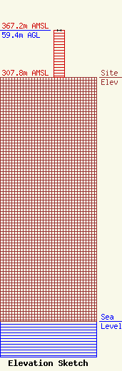
Site Elevation: 307.8 meters (1010 ft) |
| Height of Structure: 59.4 meters (195 feet) |
| Overall Height Above Ground: 59.4 meters (195 feet) |
| Overall Height Above Mean Sea Level: 367.2 meters (1205 feet) |
| Owner Info | WISCONSIN ELECTRIC POWER COMPANY
333 WEST EVERETT ST.
2046
MILWAUKEE, WI 53201-2345
(414) 221-2081
Christopher.Buckmaster@wecenergygroup.com |
| Contact Info | WISCONSIN ELECTRIC POWER COMPANY
333 WEST EVERETT ST.
2046
MILWAUKEE, WI 53201-2345
(414) 221-2081
Christopher.Buckmaster@wecenergygroup.com |
