|
|
Antenna Structure Registration 1050210 |
 |
Registration Info | Registration Number: 1050210 |
| File Number: A0873257 |
| FAA Study: SW-OE-2530 |
| FAA Issue Date: 03/27/1962 |
| Status: Constructed |
| Date Constructed: 06/01/1962 |
| FAA EMI: N |
| NEPA: N |
Structure Info
| Structure Type: TOWER |
| Structure Coordinates: 35-13-20.0 N 93-10-9.0 W (NAD 83) |
| Structure Coordinates: 35-13-19.7 N 93-10-08.4 W (Converted to NAD 27) |
| Structure Address: 615 Hwy 22 |
| Structure City: Dardanelle, AR |
| Structure County: Yell County |
| Painting & Lighting Info |
FCC Paragraph(s): 1, 3, 12, 21 |
Remarks: RED LIGHTS/PAINT |
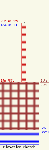
| Elevation Info |
Site Elevation: 99 meters (325 ft) |
| Height of Structure: 123.4 meters (405 feet) |
| Overall Height Above Ground: 123.4 meters (405 feet) |
| Overall Height Above Mean Sea Level: 222.4 meters (730 feet) |
| Owner Info | EAB of Russellville, LLC
2758 Highway 64
Wynne, AR 72396
(870) 238-8141
bobbycaldwell@cablelynx.com |
| Contact Info | Womble Carlyle Sandridge & Rice, LLP
1200 19th Street, NW, Fifth Floor
Washington, DC 20036
(202) 857-4455
jgarziglia@wcsr.com |
