|
|
Antenna Structure Registration 1050832 |
 |
Registration Info | Registration Number: 1050832 |
| File Number: A1063893 |
| FAA Study: 83-ASW-1844-OE |
| FAA Issue Date: 10/24/1984 |
| Status: Constructed |
| Date Constructed: 12/20/1984 |
| FAA EMI: N |
| NEPA: N |
Structure Info
| Structure Type: TOWER |
| Structure Coordinates: 35-12-4.0 N 101-50-3.0 W (NAD 83) |
| Structure Coordinates: 35-12-03.8 N 101-50-01.3 W (Converted to NAD 27) |
| Structure Address: 12th And Pierce Sts |
| Structure City: Amarillo, TX |
| Structure County: Potter County |
| Painting & Lighting Info |
FAA Circular #: 70/7460-1F |
FAA Chapters: 3, 4, 5, 9 |
Remarks: RED LIGHTS/PAINT |
| Elevation Info |
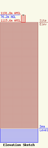
Site Elevation: 1115.6 meters (3660 ft) |
| Height of Structure: 73.2 meters (240 feet) |
| Overall Height Above Ground: 76.2 meters (250 feet) |
| Overall Height Above Mean Sea Level: 1191.8 meters (3910 feet) |
| Owner Info | KVII Licensee, LLC
Pillsbury Winthrop Shaw Pittman LLP
Washington, DC 20036
(202) 663-8195
miles.mason@pillsburylaw.com |
| Contact Info | KVII Licensee, LLC
Pillsbury Winthrop Shaw Pittman LLP
Washington, DC 20036
(202) 663-8195
miles.mason@pillsburylaw.com |
